Scattered thunderstorms, gusty winds potential in Massachusetts on Thursday
Affect Climate: Scattered thunderstorms, gusty winds potential in Massachusetts on Thursday
THE BEACH. PERFECT PLACE. WHAT A START THIS MORNING. OKAY, SO GORGEOUS OUT THERE. GORGEOUS SKY RIGHT NOW. WORCESTER AND BOSTON ENJOYING A BEAUTIFUL SUNRISE. THIS IS GOING TO BE ONE OF THOSE TOP TEN WEATHER DAYS ON OUR RADAR. BEAUTIFUL STRETCH WITH SUNSHINE AND LOW HUMIDITY. ENJOY YOUR TUESDAY. GET OUTSIDE IF YOU CAN. NEXT THING WE’RE WATCHING IS MIDWEEK, ESPECIALLY ON THURSDAY. THAT IS OUR BEST CHANCE THIS WEEK OF SEEING ANY SHOWERS AND THUNDERSTORMS. BUT HEY, GOOD TIMING BECAUSE THE WEEKEND LOOKING WARM AND MOSTLY DRY. AND WE’LL TAKE THAT OF COURSE ON A WEEKEND WE DO NEED THE RAINFALL. AS YOU KNOW, IT IS 50 DEGREES IN ORANGE. WE’RE 61 IN BOSTON, 59 IN FALMOUTH. TEMPERATURES A LITTLE COOLER THAN YESTERDAY MORNING, BUT IT’S DRY, COMFORTABLE OUTSIDE. SKIES ARE MAINLY CLEAR AND THEY’RE GOING TO STAY THAT WAY HERE TODAY WITH A BIG AREA OF HIGH PRESSURE IN CONTROL. NOW I WANT TO WIDEN OUT THE VIEW AND SHOW YOU THIS AREA OF RAIN DOWN ALONG THE GULF COAST FROM TEXAS TO LOUISIANA, STRETCHING UP INTO MISSISSIPPI. THIS IS AN AREA THAT IS GOING TO SEE MORE RAIN OVER THE NEXT COUPLE OF DAYS. IN FACT, WHEN YOU GET INTO THIS PURPLE COLOR, I MEAN, LOOK AT THE LEGEND WE’RE TALKING ABOUT OVER A HALF A FOOT OF RAIN, POTENTIALLY. SO FLOODING A BIG CONCERN DOWN HERE. AND THIS SYSTEM IS ONE THAT THE HURRICANE CENTER IS EYEING FOR POTENTIAL DEVELOPMENT. ABOUT A 60% CHANCE THAT A DISTURBANCE OVER MEXICO RIGHT NOW, AS IT DRIFTS INTO THE GULF, GETS A LITTLE BIT MORE ORGANIZED AND COULD BECOME A SHORT FUZE TROPICAL STORM THAT WILL BRING SOME OF THAT RAINFALL TO PARTS OF LOUISIANA, MISSISSIPPI AND ALABAMA. IF IT IS GIVEN A NAME, ARTHUR IS THE FIRST NAME ON THE LIST THIS YEAR, SO WE’LL KEEP YOU POSTED ON THAT HERE LOCALLY. LOOK AT ALL THE SUNSHINE LOOKING JUST BEAUTIFUL TEMPERATURES JUMPING UP QUICK. BY LATE MORNING WE’RE IN THE LOW 70S. AND NOTICE WE HOLD IN THE 70S THIS AFTERNOON WITH A LIGHT WESTERLY BREEZE. THERE MAY BE A SEA BREEZE THAT KIND OF KICKS IN LATE IN THE DAY, BUT YOU CAN SEE THOSE TEMPERATURES COMING UP IN THE LOW TO MID 70S FROM CAPE ANN AND CAPE COD INLAND, A LITTLE CLOSER TO 80 DEGREES IS ABOUT WHERE WE SHOULD BE FOR THE MIDDLE OF JUNE. A BEAUTIFUL DAY TO BE OUTSIDE. MAINLY CLEAR. COMFORTABLE TONIGHT. ANOTHER NIGHT WHERE YOU CAN GET AWAY WITHOUT THE AIR CONDITIONING. JUST OPEN UP THE WINDOW. DOWN IN THE 50S AGAIN IN THE SUBURBS, 60 DOWNTOWN. AND TOMORROW WE’LL START TO BRING IN MORE CLOUDS MIXING WITH THE SUNSHINE. LOW RISK OF A SPOTTY SHOWER. NOTICE TEMPERATURES A LITTLE CLOSER TO THAT 80 DEGREE MARK AWAY FROM CAPE COD TOMORROW. BUT YOU CAN SEE THERE ARE MORE CLOUDS AROUND, BUT IT’S MOSTLY DRY. A FEW SPOTTY SHOWERS AT BEST IN THE AFTERNOON. I THINK YOUR OUTDOOR PLANS TOMORROW ARE JUST FINE. WE’VE GOT A FRONT THAT’S CROSSING OUR AREA, BUT IT’S PRETTY LIMITED IN TERMS OF THE MOISTURE. IT HAS TO WORK WITH. ANOTHER FRONT FOLLOWS ON THURSDAY AND AS THIS WARM FRONT COMES THROUGH IN THE MORNING, THERE COULD BE SOME STEADIER SHOWERS AROUND. BUT DURING THE AFTERNOON, THE POTENTIAL OF A FEW SEVERE STORMS IN THE AFTERNOON HOURS. SO I’VE MADE THURSDAY AN IMPACT WEATHER DAY. THOSE MORNING SHOWERS COULD SLOW THE COMMUTE. SCATTERED AFTERNOON SHOWERS ARE THE ONES THAT COULD TURN SEVERE WITH SOME DAMAGING WINDS, BUT YOU CAN SEE THE TIMING ON THIS IS 9:00 IN THE MORNING ON THURSDAY. SO THAT MORNING COMMUTE COULD BE A LITTLE BIT WET. WE’LL TAKE ANY RAIN WE CAN GET AND THEN WATCH FOR THOSE POTENTIAL THUNDERSTORMS IN THE AFTERNOON. TOTAL RAINFALL DOESN’T LOOK TO BE ALL THAT SIGNIFICANT HERE IN SOUTHERN NEW ENGLAND. NOT THINKING. WE SEE MUCH MORE THAN ABOUT A QUARTER TO A HALF AN INCH, BUT WE’LL TAKE ANYTHING WE CAN GET HERE. IMPACT WEATHER ON THURSDAY AND THEN BEHIND IT. GOOD TIMING. WE’RE DRYING THINGS OUT BACK INTO THE MID 80S. BREEZY ON FRIDAY F
Affect Climate: Scattered thunderstorms, gusty winds potential in Massachusetts on Thursday

StormTeam 5 is monitoring Affect Climate throughout Massachusetts on Thursday. Morning showers might sluggish the commute and result in journey delays. Scattered thunderstorms are anticipated to develop through the afternoon. StormTeam 5 instruments: Radar | Map Room | Alerts | FuturecastA few of these storms might change into sturdy to extreme. Damaging winds are the first concern with the strongest thunderstorms.Hotter climate arrives Friday with breezy circumstances and temperatures working above regular. The weekend stays usually dry with sunshine, although Sunday contains a cooler coast, earlier than an opportunity of showers returns Monday. StormTeam 5’s 7-day forecast: Tuesday: Largely sunny. Excessive of 78. Wednesday: Extra clouds. Excessive of 80. Thursday: Breezy with showers potential. Affect Climate. Excessive of 82. Friday: Breezy; Juneteenth. Excessive of 86. Saturday: Breezy with sunshine. Excessive of 80. Sunday: Cooler coast with sunshine; Pleasure icon displayed. Excessive of 82. Monday: Probability of showers. Excessive of 78. Futurecast: Maps present what to anticipate within the coming hoursThese maps are primarily based on uncooked mannequin information, which is up to date robotically all through every day and is topic to vary. StormTeam 5 has Boston’s solely dwell radar scanning the skies over Massachusetts, 24/7.Add your climate images and movies
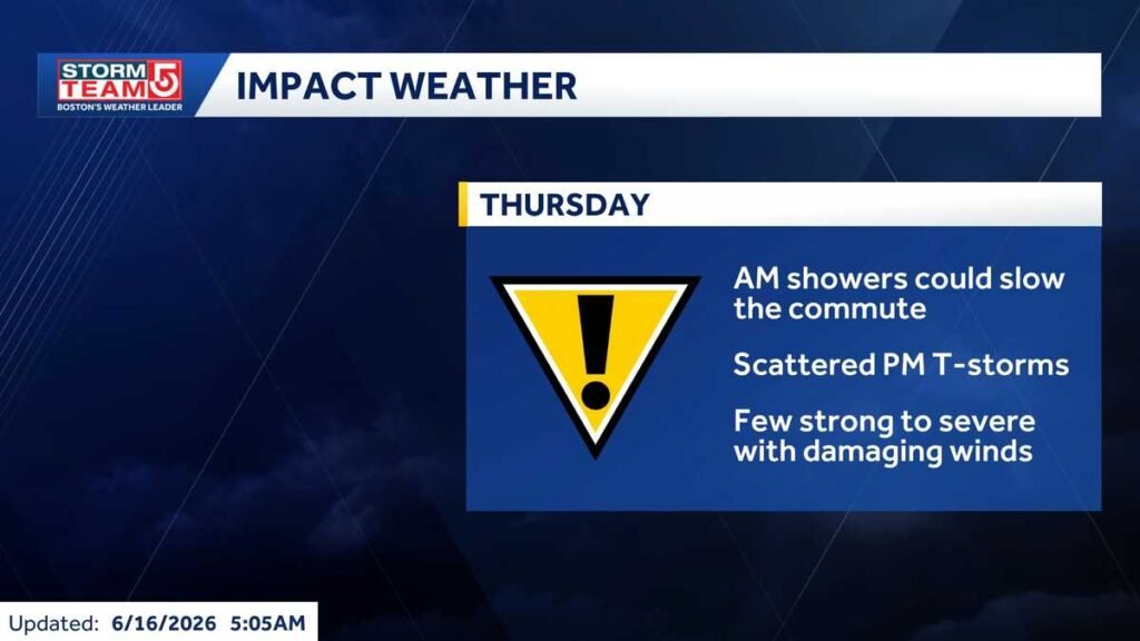
StormTeam 5 is monitoring Affect Climate throughout Massachusetts on Thursday.
Morning showers might sluggish the commute and result in journey delays. Scattered thunderstorms are anticipated to develop through the afternoon.
StormTeam 5 instruments: Radar | Map Room | Alerts | Futurecast
A couple of of these storms might change into sturdy to extreme. Damaging winds are the first concern with the strongest thunderstorms.
Hotter climate arrives Friday with breezy circumstances and temperatures working above regular.
The weekend stays usually dry with sunshine, although Sunday contains a cooler coast, earlier than an opportunity of showers returns Monday.
StormTeam 5’s 7-day forecast:
- Tuesday: Largely sunny. Excessive of 78.
- Wednesday: Extra clouds. Excessive of 80.
- Thursday: Breezy with showers potential. Affect Climate. Excessive of 82.
- Friday: Breezy; Juneteenth. Excessive of 86.
- Saturday: Breezy with sunshine. Excessive of 80.
- Sunday: Cooler coast with sunshine; Pleasure icon displayed. Excessive of 82.
- Monday: Probability of showers. Excessive of 78.
Futurecast: Maps present what to anticipate within the coming hours
These maps are primarily based on uncooked mannequin information, which is up to date robotically all through every day and is topic to vary.
StormTeam 5 has Boston’s solely dwell radar scanning the skies over Massachusetts, 24/7.