Heavy rain midweek, cool stretch into weekend

Video: Heavy rain midweek, cool stretch into weekend
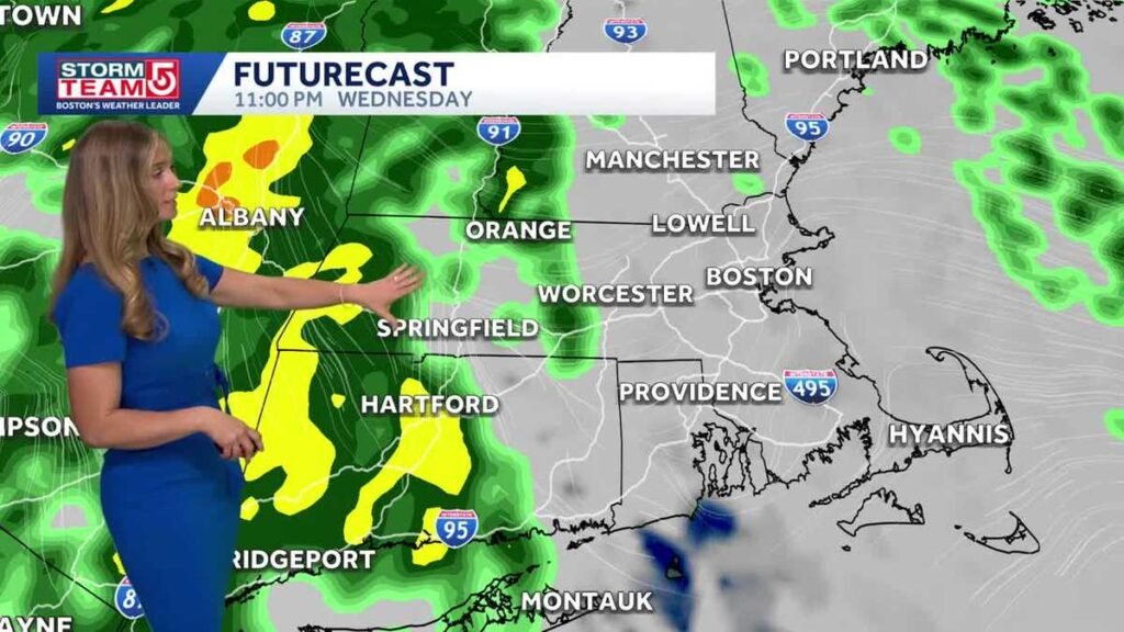
ALLSTON. AND BY. GOOD TUESDAY TO YOU. ANOTHER BRIGHT START TO OUR DAY. BUT OVER THE NEXT 12 HOURS ON OUR RADAR, WE’RE TRACKING MORE CLOUDS MOVING IN. IT’S A COOL OUTLOOK AT THE COASTLINE TO THE SEA BREEZE. OUR NEXT THREAT FOR RAIN IS GOING TO BE HEAVY AT TIMES ON THURSDAY, ESPECIALLY DURING THE MORNING HOURS, AS THE TIMELINE CONTINUES TO SHIFT EARLIER AND EARLIER. WE’RE LOOKING AHEAD TO YOUR WEEKEND. I DON’T EXPECT IT WILL BE A WASHOUT. MAYBE A SHOWER OR TWO. THE BIGGER IMPACT WILL BE THE COOL TREND THAT’S SETTLING IN FOR THE SECOND HALF HOUR WORKWEEK AND INTO THE WEEKEND. AS WE’RE KICKING OFF THE MONTH OF MAY. WE HAVE HIGH TEMPERATURES TODAY IN THE LOW 50S AT THE COASTLINE, WITH THE SEA BREEZE IN PLACE, JUST ABOUT 54 FOR BOSTON. BUT INLAND WE MANAGE TO HIT JUST ABOUT 60 THIS AFTERNOON, SLIGHTLY WARMER AS YOU MOVE FARTHER WESTWARD CONNECTICUT RIVER VALLEY INTO THE UPPER 60S, MAYBE HITTING 70 IN THE WARMEST SPOTS. YESTERDAY WAS A TAD WARMER. WE ACTUALLY SAW THROUGH MANY AREAS OF CENTRAL MASSACHUSETTS AND INTO SOUTHERN NEW HAMPSHIRE. TEMPERATURES NEARING 70 DEGREES. SO IT’S A BIT COOL DOWN FOR TODAY. AND THAT COOLDOWN CONTINUES INTO TOMORROW. THAT’S IT. WE’RE TRACKING MORE CLOUDS MOVING IN LATE TODAY AHEAD OF SUNSET. THOSE CLOUDS RIGHT NOW ARE SITTING OUT TO OUR WEST OVER NEW YORK AND PENNSYLVANIA. AND YOU CAN SEE THERE’S CLEARLY SOME SIGNS OF RAIN MOVING IN WITH THAT. BUT A LOT OF THAT FALLS APART AS IT MOVES TOWARD US. WE STILL HAVE THE INFLUENCE OF HIGH PRESSURE IN PLACE. SO WE SEE THIS SHIELD OF CLOUDS MOVING IN, PRODUCING MORE OF A MILKY APPEARANCE TO OUR SKY NEAR SUNSET, BUT NOT MUCH IN THE WAY OF RAIN. OVER THE NEXT 24 HOURS, WITH SOME LOWER CLOUDS MOVING IN OFF THE WATER OVERNIGHT TONIGHT INTO TOMORROW MORNING, YOU MIGHT WANT TO WATCH FOR SOME PATCHY DRIZZLE AT THE COASTLINE. I THINK A FEW COASTAL DROPS CAN’T BE RULED OUT FOR YOUR WEDNESDAY, BUT OUTSIDE OF THAT, IT’S RELATIVELY QUIET. IT IS COOLER TOMORROW. MORE CLOUDS IN PLACE, HIGH TEMPERATURES STRUGGLE TO GET THROUGH THE 50S EVEN AS YOU TRAVEL INLAND. HERE WE ARE, 8 A.M. ON YOUR WEDNESDAY. WE’RE LOOKING MAINLY DRY OUTSIDE OF THAT POTENTIAL FOR A FEW AREAS OF DRIZZLE AT THE COAST. YOU CAN SEE AS WE MOVE TOWARD LATE ON YOUR WEDNESDAY NIGHT, JUST ABOUT 11:00 MIDNIGHT RAIN IS STARTING TO MOVE INTO WESTERN MASSACHUSETTS, AND THAT’S A WALL OF RAIN THAT WE’RE TRACKING RIGHT ON INTO YOUR THURSDAY. I DO EXPECT IT WILL BE HEAVIEST DURING THE MORNING HOURS. THIS IS THE AFTERNOON ON THURSDAY. SO AROUND TWO, 3:00, MAYBE A SPOT SHOWER OR TWO. BUT CLEARLY THE HEAVIEST OF THE RAIN IS MOVING THROUGH IN THE MORNING. AND THAT COULD PRODUCE A SOLID HALF AN INCH TO AN INCH OF RAINFALL. WE DRY OUT HEADING INTO YOUR TUESDAY WITH SOME BREAKS OF SUN, BUT HOLDIN
Tuesday within the Boston space brings cooler situations with some late-day clouds, adopted by a cooler Wednesday with rain arriving at night time throughout Massachusetts. Thursday turns moist and funky with the steadiest rain of the week. Skies start to clear Friday, main right into a cool however brighter Saturday. One other probability for showers returns Sunday earlier than milder air arrives Monday.StormTeam 5 instruments: Radar | Map Room | Alerts | FuturecastStormTeam 5’s 7-day forecast: Tuesday: Cooler on the coast with late clouds. Excessive of 60. Wednesday: Cooler on the coast with rain creating at night time. Excessive of 57. Thursday: Moist and funky situations. Excessive of 54. Friday: Clearing skies (Could 1st). Excessive of 58. Saturday: Cool with a mixture of solar and clouds. Excessive of 58. Sunday: Probability of showers. Excessive of 56. Monday: Milder with partial sunshine. Excessive of 62.Futurecast: Maps present what to anticipate within the coming hoursThese maps are based mostly on uncooked mannequin information, which is up to date robotically all through every day and is topic to vary. StormTeam 5 has Boston’s solely dwell radar scanning the skies over Massachusetts, 24/7.Add your climate photographs and movies
Tuesday within the Boston space brings cooler situations with some late-day clouds, adopted by a cooler Wednesday with rain arriving at night time throughout Massachusetts.
Thursday turns moist and funky with the steadiest rain of the week. Skies start to clear Friday, main right into a cool however brighter Saturday. One other probability for showers returns Sunday earlier than milder air arrives Monday.
StormTeam 5 instruments: Radar | Map Room | Alerts | Futurecast
StormTeam 5’s 7-day forecast:
- Tuesday: Cooler on the coast with late clouds. Excessive of 60.
- Wednesday: Cooler on the coast with rain creating at night time. Excessive of 57.
- Thursday: Moist and funky situations. Excessive of 54.
- Friday: Clearing skies (Could 1st). Excessive of 58.
- Saturday: Cool with a mixture of solar and clouds. Excessive of 58.
- Sunday: Probability of showers. Excessive of 56.
- Monday: Milder with partial sunshine. Excessive of 62.
Futurecast: Maps present what to anticipate within the coming hours
These maps are based mostly on uncooked mannequin information, which is up to date robotically all through every day and is topic to vary.
StormTeam 5 has Boston’s solely dwell radar scanning the skies over Massachusetts, 24/7.